
The Streamwatch Program
Become a Steward of Your Local Stream
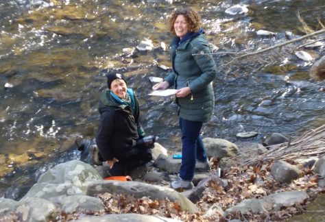
BWA’s very first program, still going strong after three decades, is our all-volunteer Streamwatch Program. Since the beginning, this effort has been powered by the commitment and dedication of community members who care deeply about the streams flowing past their homes.
Each month, these volunteers lace up their boots, walk down to the water, and gather the data that helps us understand the long-term health of our waterways, which helps paint a clear picture of how our streams might be changing over time.
The true magic of the Streamwatch Program is the quiet, everyday stewardship that comes from people who take notice… when the water runs a little warmer, when a bank begins to erode, or when something just feels different. Their eyes and ears out there, month after month, is one of the most powerful protections our High Quality and Exceptional Value streams have.
Today, nearly 100 sites across the watershed are monitored through this program, each one cared for by someone who has made their stream a personal responsibility.
The Importance of Monitoring
The Brodhead Watershed is a forested, headwaters-rich watershed in the heart of the Pocono Mountains of northeastern Pennsylvania. It covers roughly 270 square miles in Monroe County (with small portions touching Pike and Northampton Counties) and ultimately drains into the Delaware River.
The Brodhead is dominated by forest, steep ridges, cool wetlands, and clean mountain streams. Much of the water that flows into the Delaware River begins here as springs, seeps, and small tributaries. Because of the intact forests and healthy wetlands, many of the streams in this watershed are classified as High Quality (HQ) or Exceptional Value (EV) – the highest protection Pennsylvania gives to freshwater resources. The watershed is also known for exceptional trout habitat. Cool groundwater inputs and forest canopy help maintain the cold water temperatures these species rely on. Our region has a rich fishing history, with the Brodhead often called the “birthplace of American fly-fishing.”
The watershed is named for Brodhead Creek, formed by the union of two primary headwater tributaries: the Middle Branch and the Leavitt Branch, flowing south through East Stroudsburg and Stroudsburg before joining the Delaware.
Key sub-watersheds include:
Brodhead – Upper and Lower
Cherry Creek
Cranberry Creek
Marshalls Creek
McMichael Creek
Paradise Creek
Pocono Creek
Swiftwater Creek
Each of these has its own network of tributaries and headwaters that feed the mainstem Brodhead.
The Brodhead provides:
Clean drinking water for thousands
Critical trout and wildlife habitat
Flood protection for downstream communities
Scenic, recreational spaces for hiking, paddling, angling, and more
A living connection to the natural and cultural heritage of the Poconos
BECOME A STREAMWATCHER
What’s it like to be a Streamwatcher? Click HERE for a summary of what these vital volunteers do.
Current streamwatch volunteer?
Check out our VOLUNTEER PAGE.
Please note: this page is password-protected. You can obtain the password from your Streamwatch Team Lead.

2024 Streamwatch Summer Snapshot Report
View the 2024 Report results HERE
STREAMWATCH SITES:
in the BRODHEAD CREEK (MAP – UPPER) (MAP – LOWER)
in the MCMICHAEL CREEK WATERSHED (McMichael map 2020)
in the PARADISE CREEK WATERSHED ( MAP)
in the POCONO CREEK WATERSHED (MAP)
in the MARSHALLS CREEK WATERSHED (MAP)
in the CHERRY CREEK WATERSHED (MAP)
30 Years of Streamwatch Data
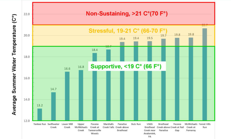
SUMMER FECAL COLIFORM MONITORING
MONROE COUNTY WATER QUALITY REPORTS
To view the last three years of Monroe County Water Quality Reports, click HERE
Everyone can be a steward.
Who to Call When
The steps to take and the proper authority(s) to call when you see what you believe is a problem with a stream.