Explore Your Watershed:
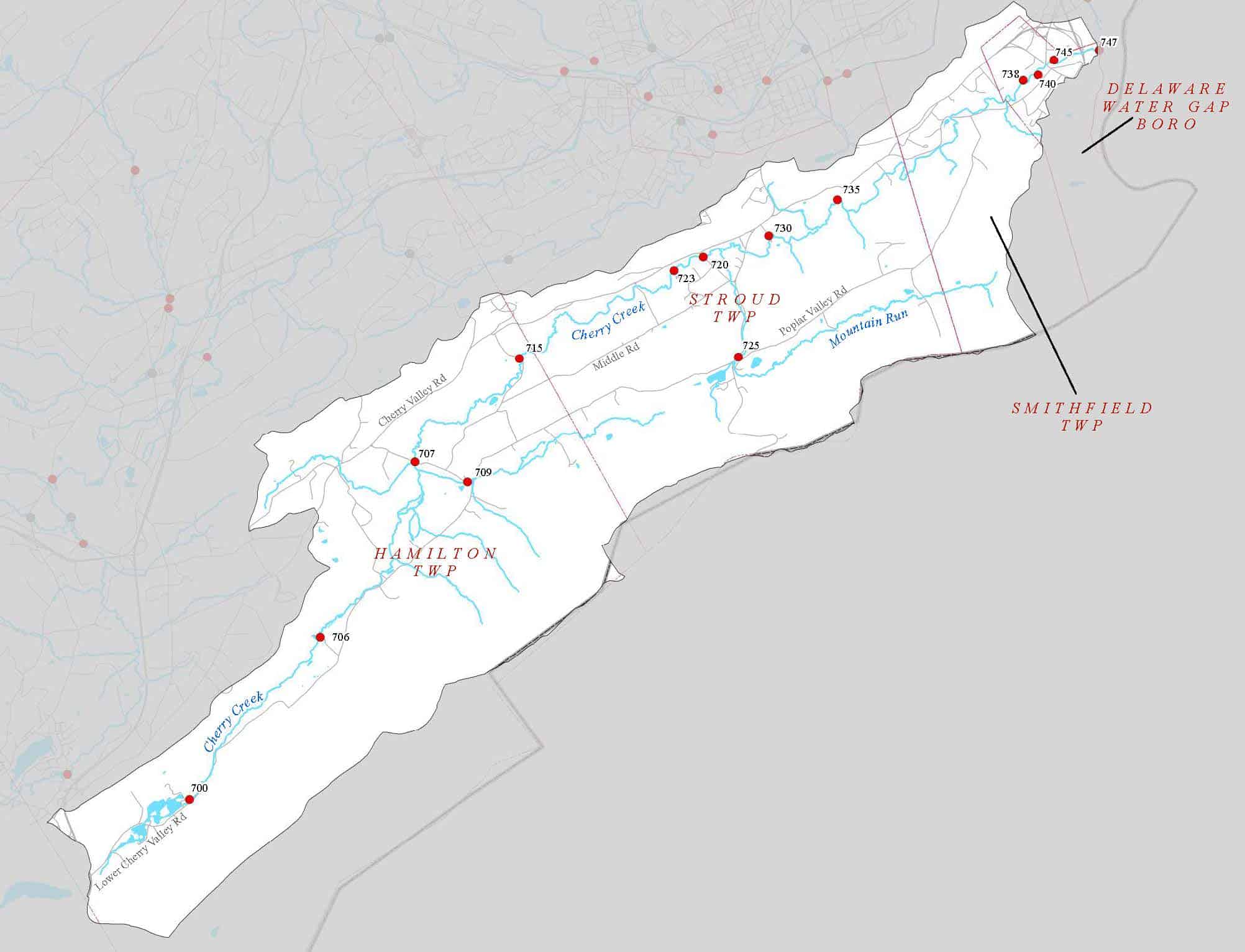
The Cherry Creek Subwatershed
Drainage Area: 30.5 square miles
Brodhead Watershed, Monroe County, PA
MUNICIPALITIES IN THE WATERSHED
Smithfield Township
Stroud Township
Hamilton Township
Delaware Water Gap Borough
NAMED STREAMS
Cherry Creek
Mountain Run
NAMED LAKES, PONDS, AND IMPOUNDMENTS
Witmers Lake/Twin Lakes
Do you know?
The Cherry Creek watershed includes Mountain Run and a number of unnamed tributaries that drain north from the Kittatinny Ridge and south from Godfrey’s Ridge to Cherry Creek in the valley floor. The watershed covers 30.5 square miles.
Cherry Creek is a second order valley stream that originates above Twin Ponds just east of Route 33 and south of Saylorsburg. The flow is substantially increased by large springs located a short distance downstream from the pond outflow and above the Cherry Valley Trout Hatchery. The creek meanders for approximately 15 miles through the narrow, steep-sided Cherry Valley, eventually emptying into the Delaware River at Delaware Water Gap. The elevation change from source to mouth is only about 370 feet.
Cherry Creek is classified as a High Quality Coldwater Fishery according to the PA Department of Environmental Protection. The creek supports a total of 15 fish species including reproducing brown, brook and rainbow trout populations along its entire length, with numbers decreasing from source to mouth. This is likely due to a decline in habitat quality, perhaps because of warmer water temperatures, and to the lack of pools, the scarcity of boulders and cobbles and some sand-gravel deposits that cause low velocity flats.
The largest landholding in Cherry Valley is the land formerly owned by PA American Water Company, with 3370 acres near the creek source. That land is now owned by the Fish and Wildlife Service and is part of the Cherry Valley National Wildlife Refuge. The Nature Conservancy owns and manages several properties and conservation easements in Cherry Valley.
A single point source discharge to Cherry Creek is located in Delaware Water Gap. Two public water supply wells serve about 700 Delaware Water Gap residents while most of the valley population depends on private wells and on-site septic systems. A winery, apiary, several restaurants, a golf course, individual homes and small developments and number of active farms are the primary commercial operations in the watershed.
Delaware Water Gap is a popular rest stop on the Appalachian Trail.
The Pocono Wildlife Rehab Center, licensed by both Fish and Wildlife Service and PA Game Commission operates at 1161 Cherry Drive, Stroudsburg. Josie Porter Farm, provides locally grown vegetables, fruits, meats, dairy, eggs and more from local farm partners.
The Cherry Valley substrate is primarily gravel, sand and silt with scattered cobble and boulders located in higher gradient riffle areas where scouring occurs. The underlying geology is a complex of limestone, shale and siltstone overlain with unconsolidated glacial deposits of silt, sand and gravel in the valley. Because of the limestone formations, Cherry Creek has a much higher pH, alkalinity and total dissolved solids than is found in most Pocono area streams, which generally are acidic with a low mineral content.
Riparian vegetation is well established and stable, varying between trees that provide a thick canopy on the upper and lower stream to woody bushes that create heavy bankside overhang, especially in the mid-valley area.
MORE INFO:
– More info about the NWR at http://www.monroecountypa.gov/Dept/Planning/Pages/CherryValley.aspx
– Visit the NWR site at https://www.fws.gov/refuge/cherry_valley/
– Find automated (real time) data loggers on Cherry Creek. Visit Monitormywatershed , and search for East Stroudsburg University
Find hikes in Cherry Valley at BWA’s Get Outdoors Poconos page
– Browse the Cherry Creek River Conservation Plan