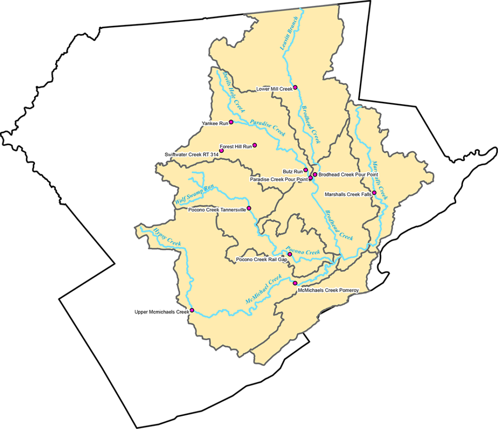
Skip to content
BWA logo
  • Home
  • About
    • Contact Us
    • Board of Directors
    • Committees
    • Staff
    • History
    • Reports and Plans
    • Finances
    • Annual Reports
  • Events
  • PROGRAMS
    • Streamwatch
    • EXPLORE YOUR WATERSHED
    • Green Infrastucture
    • Get Outdoors Poconos
    • MS4/Municipal Assistance
    • Plant Native
    • Climate Change Issues
    • Protecting Clean Water Together
    • Nature at Risk
    • Invasive Plant of the Month
    • More Programs
  • Projects
    • Mill Creek Project
    • Greening Mountainhome
    • PLAN FOR CLEAN WATER
    • GREEN INFRASTRUCTURE PLAN
    • Upper-Brodhead-Paradise Trail Study
    • Project Headwaters
    • More Projects
  • SUPPORT
    • Become a Member
    • Conservation Partnership
    • Planned Giving
  • News
    • PRESS
    • Most Recent E-Newsletter
    • Newsletter Archive
    • Environmental Alerts
    • REPORT ON MCCD
    • Feature Stories
Menu
  • Home
  • About
    • Contact Us
    • Board of Directors
    • Committees
    • Staff
    • History
    • Reports and Plans
    • Finances
    • Annual Reports
  • Events
  • PROGRAMS
    • Streamwatch
    • EXPLORE YOUR WATERSHED
    • Green Infrastucture
    • Get Outdoors Poconos
    • MS4/Municipal Assistance
    • Plant Native
    • Climate Change Issues
    • Protecting Clean Water Together
    • Nature at Risk
    • Invasive Plant of the Month
    • More Programs
  • Projects
    • Mill Creek Project
    • Greening Mountainhome
    • PLAN FOR CLEAN WATER
    • GREEN INFRASTRUCTURE PLAN
    • Upper-Brodhead-Paradise Trail Study
    • Project Headwaters
    • More Projects
  • SUPPORT
    • Become a Member
    • Conservation Partnership
    • Planned Giving
  • News
    • PRESS
    • Most Recent E-Newsletter
    • Newsletter Archive
    • Environmental Alerts
    • REPORT ON MCCD
    • Feature Stories
Search

REAL TIME DATA FROM AROUND THE WATERSHED

Automated data monitoring stations are installed around the watershed and transmit data (via a cell phone link) to the Monitor My Watershed website, where it can be viewed on your phone or computer. More Information

Mill Creek at Brodhead confluence

Yankee Run below Mt. Pocono Five-Points intersection

Swiftwater below Rt 314, above Indian Run confluence

Forest Hills Run at Red Rock Road

Butz Run above Paradise confluence

Paradise above Brodhead confluence

Brodhead above Paradise confluence

Pocono at Tannersville, above Route 715

Pocono at Rail Gap Preserve

Upper McMichael Creek

Lower McMichael Creek, Pomeroy Preserve

Marshalls Creek at Marshalls Falls

Click Here
Previous
Next

Download pdf.

CONDUCTIVITY & CHLORIDE MONITORING PROJECT

+ WHY  WE MONITOR CHLORIDE

+ SUMMARY OF 2018-2019 CHLORIDE TESTING

+WHY WE MONITOR CONDUCTIVITY

+VIEW BWA CONDUCTIVITY DATA

For the latest news & updates

Click here to sign up for BWA's monthly e-newsletter!
Get BWA T-shirts & More
Facebook Instagram Twitter Youtube

Board Tools | Board/Committee Minutes 

Brodhead Creek Heritage Center

info@brodheadwatershed.org | 570-839-1120 | postal: PO Box 339, Henryville, PA 18332 | physical: 1539 Cherry Lane Road, East Stroudsburg, PA 18301.

Copyright © 2023 Brodhead Watershed Association – All Rights Reserved