![]()
![]()
![]()
![]()
![]()
![]()
![]()
![]()
![]()
![]()
![]()
![]()
![]()
![]()
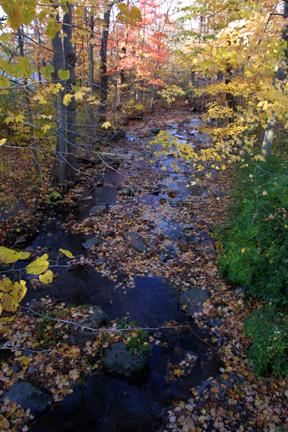
Cherry Creek
Watershed
Current Land Use
 Current land use in Cherry Valley is limited to residential development along with a number of scattered commercial enterprises located near the headwaters area at Saylorsburg and at the mouth in Delaware Water Gap. The entire watershed is heavily forested, and agricultural use is limited to the drier sections of the floodplain extending back to the base of the mountains, mostly in the upper and mid-valley region. Three golf courses are located in or near Delaware Water Gap.
The single point source discharge into the creek is from Laird Technologies, a manufacturer of high performance shielding for a broad range of engineered components for the electronics and building industries. The company was recently known as Instrument Specialties; the name changed after its sale in 2000 to a British company.
The entire Cherry Valley area is now undergoing intensive residential home construction, and many tracts of land are now available for sale through Pocono area realtors. In the mid-valley area, a large working farm operates on both the north and south banks of Cherry Creek. A commercial trout hatchery operates near the headwaters area.
Largest Landowner
Citizens Utility, Inc. is the largest landowner in Cherry Valley; they own 3,370 acres on the western end of the Valley where wells and two reservoirs are located. Citizens purchased the property in the 1970s from Blue Mountain Water Company who had owned the land since the early 1900s. In the valley, Citizens only taps four of the many springs existing on their property, and they use the water for backup only, generally during the summer months when other sources are low. They maintain a pumping station to move the water through pipes, most of which are located on the surface, up and over the Blue Mountain ridge into Wind Gap and Nazareth.
Permits are in place to withdraw 780 million gallons of water per year from surface sources (streams, springs) and 74 million gallons per year from wells. The company maintains an entitlement with the Delaware River Basin Commission; that is, the company is exempt from making payments to DRBC for water withdrawal because it is "grandfathered", incorporated earlier than the 1961 DRBC Compact. Blue Mountain Water Company earlier owned this tract.
